Iberian settlements
Urbanism, villages and construction systems of Iberian culture
At the Iron Age in the northeast of the Iberian Peninsula there was a solid structure of settlements of several dimensions scattered throughout the territory. First order nuclei were monumental fortified villages, covering an area of 8 to 15 ha. From these main nuclei, and interconnected through trade routes, there were settlements of second order, smaller villages of around 2 to 4 ha. Finally, the third order ones constituted smaller structures, with an area of 0.5 to 1 ha which would be citadels, farms or small rural villages and forts to control the territory, ie, specialized centers.
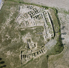 |
The structure of the villages was adapted to the area characteristics and influenced the layout of streets. Typology varied according to the villages placed on top of the hills, on the slopes or on the plain. The common plain was a perimeter wall with houses adjoining the wall and separated by party walls, grouped in blocks divided by streets. From the 6th century BC we can find more complex orthogonal drawns. |
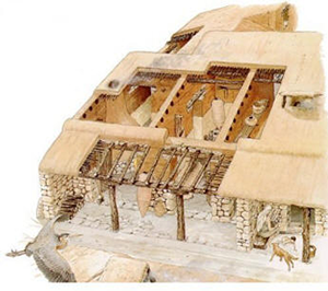
The houses were built directly on the rock, and their foundations and base of walls were made of stone. The top part of the thicker walls, and all general walls were made of adobe (a mixture of clay, sand, water and straw). Rammed earth was also used (mixture of clay, sand and stones) whiten with lime to waterproof them. Sometimes the walls were decorated. The houses could be one floor or two floors tall. The roofs were made of wooden beams, branches and reeds covered with clay, although mortar was also used to waterproof roofs, which could be flat or inclined with one or two slopes to facilitate the evacuation of rain. The Iberians had sophisticated systems to collect groundwater and surface water, a good example can be seen in the village of Molí de l'Espígol (Urgell). In the oldest villages, 7th century BC, the houses had one only room where all functions were developed. Later on we find houses with several rooms with different functions: kitchen, lounge area, storage area, work areas. |
 |
Tribes and main archeological sites
Greek and Latin sources speak of an Iberian ethnic composed of different tribal structures. On the southeast and east of the peninsula they describe power elite that controlled the production and trade of various fortified villages. On the other hand, on the northeast, villages were governed by the Senate, by councils of elders or by leading members of groups of the village.
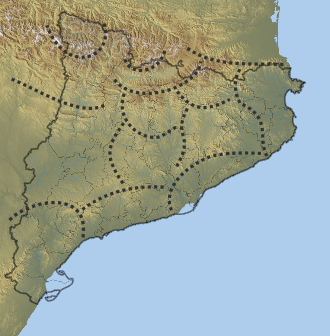
The main coastal Iberian tribes from north to south, were:
- Sordones and Elisyces, on the Roussillon and Languedoc, France. The most important archeological sites are:
- fortified village of Pech Maho, Sigean, Aude (6th-3rd centuries BC.)
- fortified village, necropolis and fields of silos of Ensérune (6th c. BC - 1st c. AD.)
- Indigetes or Indiketes, on the Bay of Roses until the Pyrenees occupying the surrounding Gerundese region of La Selva, Empordà and Gironès. The most important archeological sites are:
- fortified village of Mas Castellà and fields of silos, Pontós, Alt Empordà (5th-2nd centuries BC.)
- Iberian city of Ullastret, at Puig de Sant Andreu, village of Illa d’en Reixac, and necropolis on Puig d’en Serra, Baix Empordà (3rd-2nd centuries BC.)
- silos and village of Sant Sebastià de la Guarda, Palafrugell, Baix Empordà (5th-1st centuries BC.)
- fortified village of Punta del Castell, Palamós, Baix Empordà (6th-1st centuries BC.)
- fortified village of Puig Castellet, Lloret de Mar, La Selva (4th-3rd centuries BC.)
- Laietani, in the coastal area from Tordera to Llobregat, occupying the regions of Maresme and Barcelonès; pre-coastal depression of Vallès and Lower Llobregat until the north of Garraf. The most important archeological sites are:
- fortified village of Puig Castellar, Santa Coloma de Gramanet, Barcelonès (6th-2nd centuries BC.)
- fortified village of Turó d'en Boscà, Badalona, Barcelonès (6th-1st centuries BC.)
- village of Penya del Moro, Sant Just Desvern (8th-4th centuries BC.)
- village of Turó de Ca n'Olivé, Cerdanyola, on the mountain of Collserola, Vallès Occidental (6th c. - 50 BC.)
- silos and fortified village of Turó del Vent, Llinars del Vallès (4th century BC.)
- fortified villag of Burriac, Cabrera de Mar (6th-1st centuries BC.)
- Cessetani or Kessetani, in Anoia, Penedès, Camp de Tarragona and coastal area of Garraf and Tarragonès. The most important archeological sites are:
- fortified village of Sant Miquel d'Olèrdola, Alt Penedès (8th-1st centuries BC.)
- citadel of Toixoneres, Calafell, Baix Penedès (6th-2nd centuries BC.)
- village of Darró, Vilanova i la Geltrú, Garraf (5th-2nd centuries BC.)
- Ilercavones or Ilercaones, around the lower reaches of the Ebre river from Mequinenza, basin of Matarranya, Montsià and the east coast to Castellon. The most important archeological sites are:
- fortified village of Castellet de Banyoles, Tivissa, Ribera d'Ebre (4th-2nd centuries BC.)
- fortified village of Castellot de la Roca Roja, Benifallet, Ribera d'Ebre (6th-2nd centuries BC.)
- necropolis and village of Coll del Moro, Gandesa, Terra Alta (8th-1st centuries AD.)
- village of Tossal del Moro, Batea, Terra Alta (8th-3rd centuries BC.)
- fortified village of Moleta del Remei, Alcanar, Montsià (7th-2nd centuries BC.)
- fortified village of Sant Antoni el Pobre, Calaceit, Matarranya, Terol (5th-1st centuries BC.)
- fortified village and necropolis of Puig de la Nao, Benicarló, Baix Maestrat (6th-4th centuries BC.)
- fortified village of Puig de la Misericòrdia, Vinaròs, Baix Maestrat (7th-2nd centuries BC.)
- Edetani or Esdetes, at the coastal plain of the south of the province of Castelló and the coast of Valencia up to the river Xúquer. The capital was Edeta (Llíria), although the most important city was Arse (now Sagunt). South of the Edetani there were the Contestani, who occupied the eastern coast to the river Segura, and the provinces of Murcia and Albacete. There are very important archeological sites such as the village of Serreta, in Alcoi, and the Bastida de les Alcusses, in Moixent; sanctuaries of Cerro de los Santos, in Montealegre (Albacete) and The Cigarralejo, in Mula (Murcia); necropolis of los Villares, in Hoya Gonzalo (Albacete), among many others.
The main Iberian tribes of the interior were:
- Ilergetes, on the majority of the region of Lleida: Urgell, Segrià and Noguera; also in the basins of rivers Segre and Cinca from the Pyrenees to the Ebre, to the current Aragon. The most important archeological sites are:
- fortified village of Molí d'Espígol, Tornabous, Urgell (6th-2nd centuries BC.)
- fortress of Els Vilars d'Arbeca, Les Garrigues (7th-4th centuries BC.)
- fortified village of Genó, Aitona, El Segrià (Bronze Age - 9th century BC.)
- Ausetani, from the inland to the current Osona, i.e. the plain of Vic, part of Girona and Guilleries. The most important archeological sites are:
- fortified village of Turó del Montgròs, El Brull, Osona (end of Bronze Age - 1st century BC.)
- fortified village of Casol de Puigcastellet, Folgueroles (3rd century BC.)
- fortified village of Esquerda, Roda de Ter, Osona (8th-1st centuries BC.)
- Lacetani, along the river Llobregat to the regions of Bages, Segarra and Solsonès. The most important archeological site is the fortified village of El Cogulló, Sallent (7th-1st centuries BC.)
- Bargusii or Bergistani, at the Berga area. The most important archeological site is the village of Sant Miquel de Sorba, Montmajor, Berguedà (6th-3rd centuries BC.)
Sedetaniis another mentioned tribe in various sources, located at the middle of the Ebre basin, from the mouth of the river Jalón until the river of Aguas Vivas, their main archeological site is the fortified village of Cabezo de Alcalá, Azaila, Teruel (4th-1st centuries BC);Suesetani, located between Sedetani and Ilergetes, were found until the Pyrenean region where Airenosi, Andosini and Cerretani were found, in the current valleys of Vall d'Aran, Andorra and Cerdanya, respectively. There is also a tribe called Castellani situated in the area of La Garrotxa.
As for the southern Iberians, we know the Bastetani, Oretani, Turduli and Turdetani.
The Iberian route has been coordinated by the Archaeological Museum of Catalonia (MAC, as per the acronym in Catalan). It includes 17 archaeological sites structured in 7 itineraries. Information can be found in:
Ruta dels Ibers
MAPS OF THE IBERIAN CATALONIA
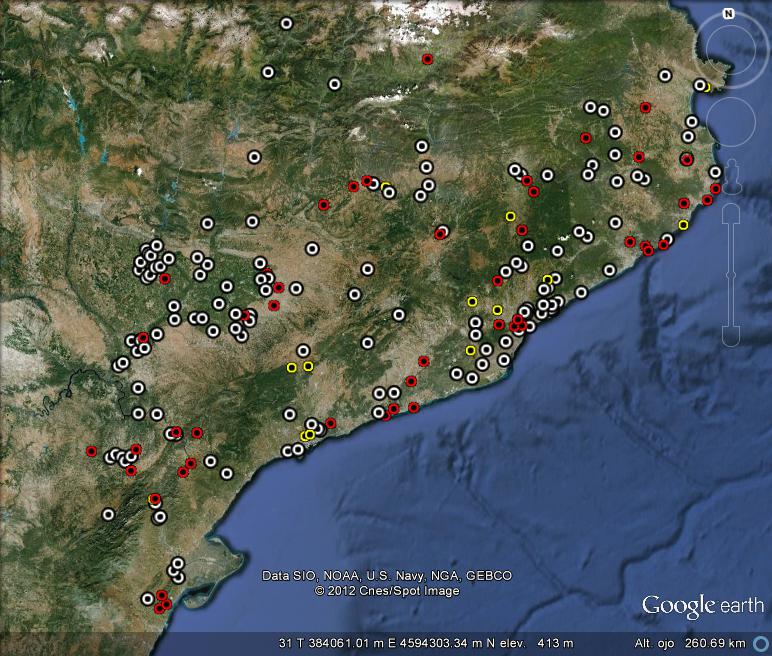
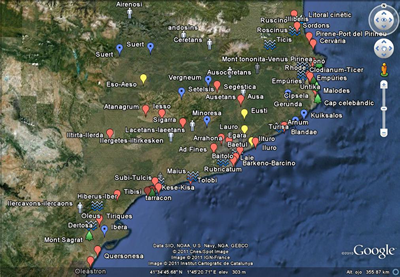
Click on the images of the maps to open or save them. If you do not have Google Earth, click to download it for free. If you don't want to install the software, you can see a simplified version of the maps here.
Map Iberian Archeological Sites |
Map According to the Classics |
 |
 |
Latest version: November 2014
360_iberian_settlements_list
Map Archeological Sites Legend
- In red: visible archeological sites (for Google Earth resolution).
- In white: non visible archeological sites, but perhaps visible at ground level.
- In yellow: other type of archeological sites.
More info + info about maps.

Webmistress: Núria Delgado.


